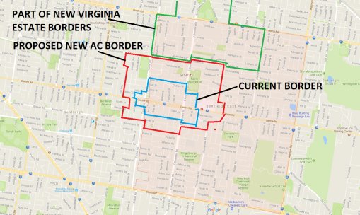
Activity centres have 5 main purposes as shown in the following screen dump from the State Government’s Practice Notes. Whilst this dates from 2015, not much has changed in the recent Plan Melbourne ‘Refresh’. Activity centres are there to facilitate further development – especially those centres which have train stations in their midst.
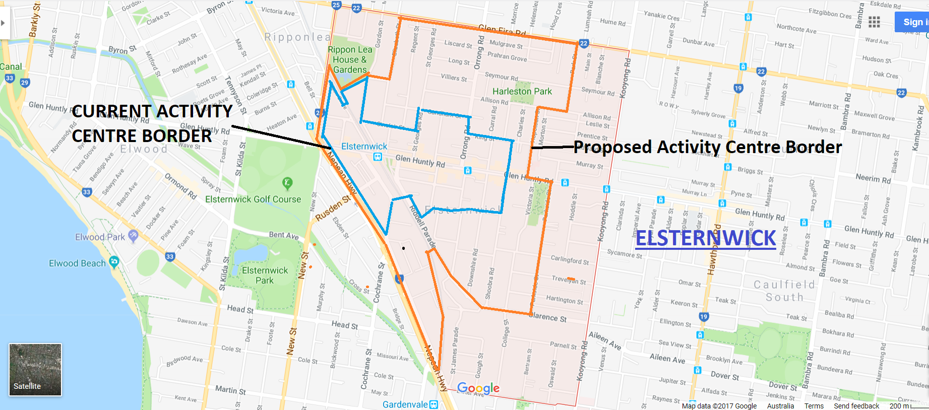
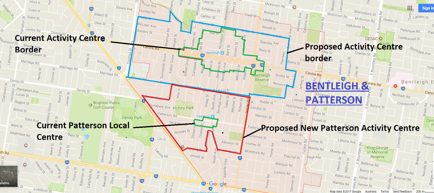
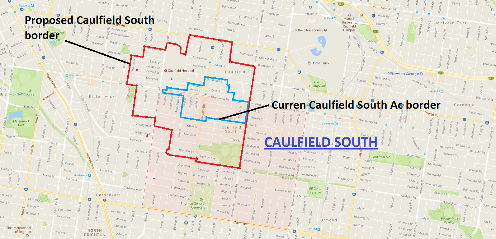
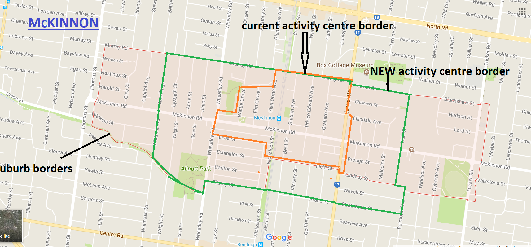
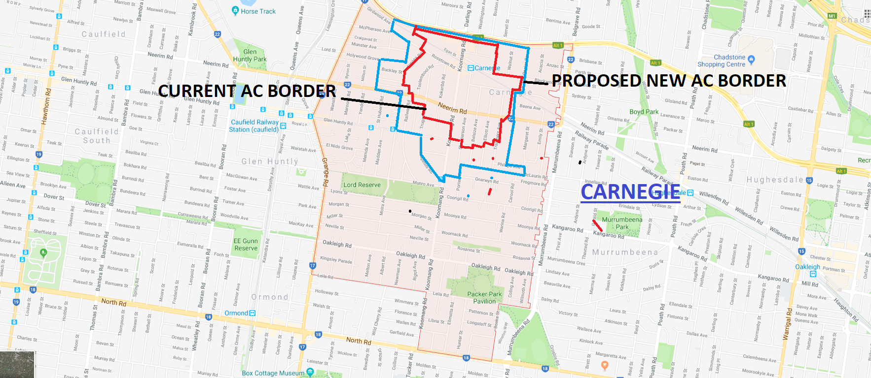
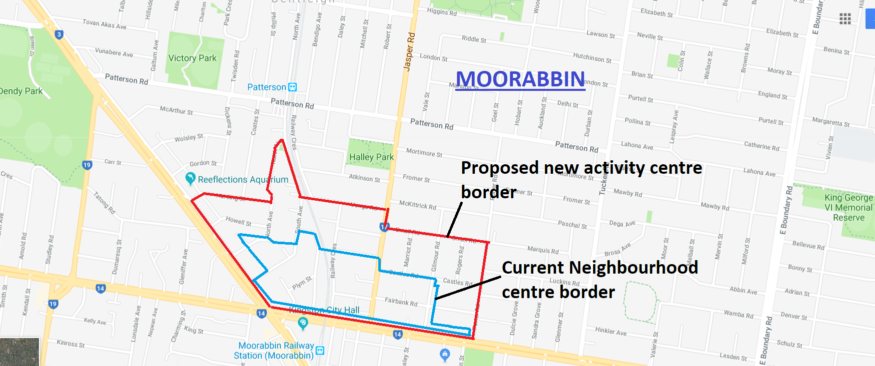
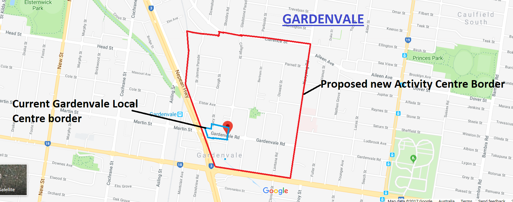
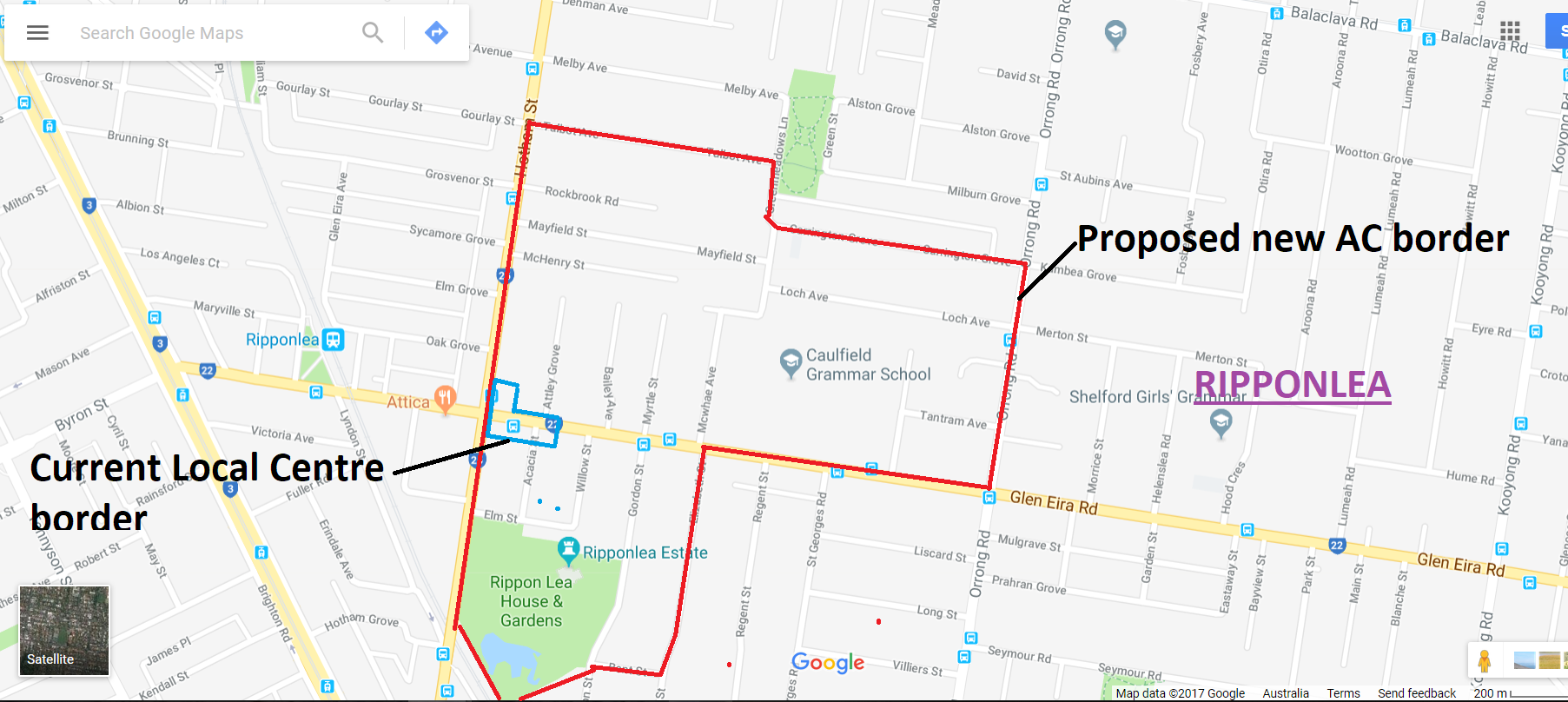
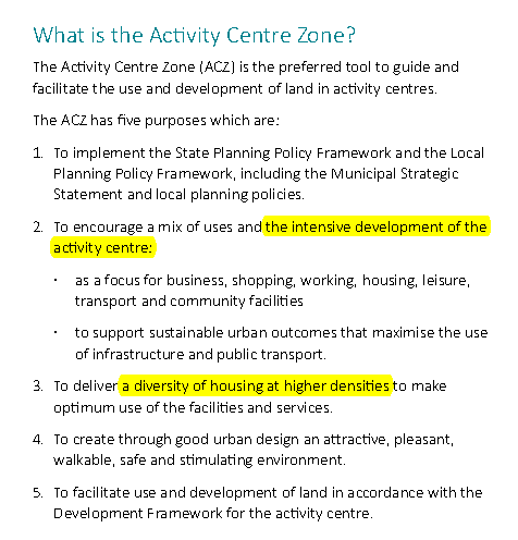 Council’s structure planning has embraced this notion completely and taken it to extremes. Land originally termed ‘study areas’ have now morphed into activity centre borders with a doubling and more in size. This is the case for Bentleigh, Elsternwick and Carnegie. We see no reason to believe that this won’t happen to our Neighbourhood Centres given council’s recent actions. It is also clear from the published documentation that 3 current Local Centres are now being expanded into Neighbourhood Centres and some Neighbourhood Centres like Bentleigh East and South Caulfield are also to bear the brunt of major development.
The result is that over 80% of Glen Eira will now become areas designated as ‘activity centres’ if our suspicions prove correct. This is unheard of in any other municipality. Further, there is absolutely no justification for this expansion of development potential given current rates of development. You don’t double or triple the size of an activity centre without some major rezoning in mind. Residents should also bear in mind that council has been far from transparent throughout this entire process. Information has been published in dribs and drabs and most of it bereft of detail. And still no word about our current neighbourhood centres.
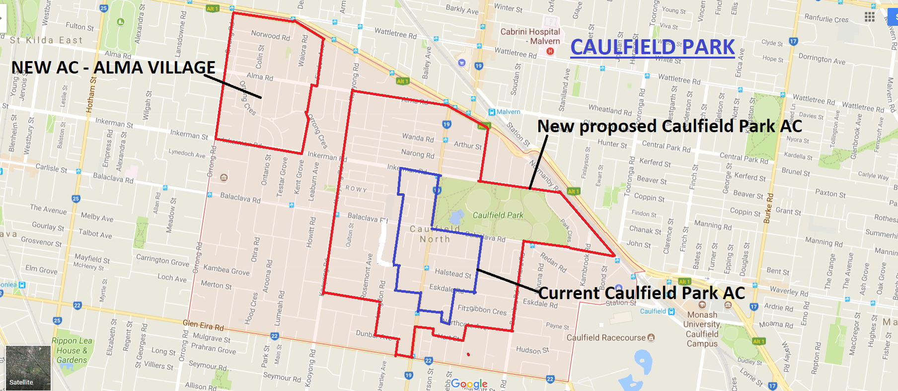
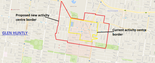
The following images are great cause for concern. Please note that in some of these images the areas shaded red represent the entire suburb. The lines drawn represent the current activity centre boundaries and the proposed new borders. Readers will see that for some suburbs they are practically ALL activity centres. Plus that many of these literally run into each other – ie Carnegie and Murrumbeena; Bentleigh and East Bentleigh. Thus we have huge swathes of land that are now ripe for the picking – in fact, 80% if all of this goes through!
CLICK TO ENLARGE


PS: WE FORGOT TO INCLUDE GLEN HUNTLY – DESIGNATED AS A MAJOR ACTIVITY CENTRE NOW INSTEAD OF A ‘NEIGHBOURHOOD CENTRE’

December 3, 2017 at 2:00 PM
It a boomtime land grab of epic proportions they developers couldn’t be happier if they drawn the plans themselves, come to think of it maybe they did
December 3, 2017 at 9:13 PM
My guess – every main road will become 3 stories. Heights in neighbourhood centres will be 6 stories like in east Bentleigh. Heaps of residential areas will become grz and all the local centre surrounds will be rgz.
December 3, 2017 at 10:53 PM
Outrageous stuff. They’ve lied through their back teeth. It’s the biggest con of residents since they brought in the zones.
December 4, 2017 at 9:50 AM
Would say the blueprint is ready to go. Moorabbin, Glen Huntly, Patterson, Ripponlea, Murrumbeena, Hughesdale, East Bentleigh and South Caulfield will bear the brunt of new zoning and major redevelopment apart from what’s already shown for Elsternwick Bentleigh and Carnegie. Read between the lines people – it’s all there in code.
December 4, 2017 at 1:24 PM
Have to agree with you Macca. Glen Huntly is now a MAC and Moorabbin is said to be ready for “urban renewal”. Rest have train stations so higher buildings, more apartments and stacks of rezoning nearby.
December 4, 2017 at 5:34 PM
Glenhuntly has been a Major Activity Centre since Melbourne 2030 was first published—check p206. What I don’t see is the justification for the massive expansion of activity centres, not when Council via Cr Hyams was prepared to tell the Government we had 85 years’ supply back in 2013. Council doesn’t know or isn’t prepared to say, how many dwellings it thinks can be squeezed in under its proposed “structure plans”.
The whole planning system is in a disgraceful state. Government doesn’t respect it, VCAT doesn’t respect it, Council doesn’t respect it. Height limits, ResCode, infrastructure capacity, basic planning processes—all widely ignored. Under the current system we’re not allowed to control rate of change, and a bunch of people who aren’t accountable keep making decisions that we the people have to fund. In the meantime the State Government has run amok, outlining road projects totalling $40B with dubious benefits and no strategy for managing costs.
One officer did hint that Council was responding to statements made by the Minister and his Department, but when presssed, denied there had been any instructions or orders received from them. I’m therefore working on the assumption that it is our current councillors pushing for the massive rezoning.
December 4, 2017 at 6:17 PM
Agreed, the councillors have never opposed development. There is heaps of evidence to highlight that GE is out of control with development but it never gets any airplay. The place is being destroyed.
December 4, 2017 at 11:33 PM
What are you going to do about it, Anon?
December 4, 2017 at 5:54 PM
Good news for the caravan place in Queens Avenue. It has been for sale forever. Now loads of apartments can be built on it. Spose it is goodbye Caulfield east
December 6, 2017 at 10:46 PM
Funny how again Caulfield north is safe at the cost of the rest of the suburbs
December 6, 2017 at 10:50 PM
If what is presented in these maps is realised then Caulfield North will also be impacted – ie expansion of the Caulfield Park area and of course the over 2000 dwellings at Caulfield Village (although technically in Caulfield East, they will surely have an effect on Caulfield Park area). There’s also the expansion of Alma Village.
December 7, 2017 at 10:13 AM
I think the majority of Caulfield “Village” is in Caulfield North, as the suburb boundary runs N-S down Smith St then E-W along Station St. The proposed 20+ storey tower, being east of Smith St, is in Caulfield East. It’s all Camden Ward though, albeit close to the fringe.